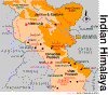
| Geography The Kumaon Himalayas lie next to the Garhwal region and are
situated on the Great Himalayan Range. Kumaon is often confused with the Garhwal region
itself. Kumaon comprises the three hill districts of Nainital, Almorah and Pithoragarh.
Garhwal and Kumaon compared to Switzerland. It is bordered by Mahakali (or Kali or Kali
Nadi) in the east towards Nepal and the districts of Pauri Garhwal and Chamoli to the
west. Tibet lies to the north and the Terai to the south. The Mahakali River, running
along its eastern boundary, forms the Indo-Nepal international border. Moving westwards,
one comes across the Panchchuli Massif, the Gori Valley, and the Pindari and Sunderdungha
valleys at the western end of Kumaon. The Kali River and its valley are prominent in
Kumaon. At one time, the Kali Valley was the standard trade route from India to Tibet,
crossing over the Lipu Lekh pass. The Mahakali originates north of the main Himalayan
range, carves its way through the Greater Himalayas and merges with the Ganga (Ganges) in
the plains.
April to June and September to November
are the best seasons to visit Almora. In fact except the rainy seasons, Almora can be
visited any time of the year. During summers the temperature of this place is
comparitively more than any other hill stations. Even then evening and morning
temperatures are low enough to wear light warm cloths. The fun of walking among hills in
warm sunlight can not be discribed in words. During winters festival of Dussherra has its
own added attraction.
The best way to access Almora is by bus.
The winding and spirilling roads take you though deep valleys and dense forests. One
enjoys the journey to Almora by bus as the speed is slow, scenic beauty of the region are
clearly visible. There are bus services to Almora from almost any |
Area
Area
|